Monday, March 21, 2011

Lake Pueblo Voodoo Fire Race Loop

Sunday morning David showed up at 7:30am to pick me up for a day of riding down in Pueblo, just a bit south of Colorado Springs. We loaded the car and noticed the wind was blowing a bit...ummm. Then I decided to throw a wrench into everything and mention that we could just save the drive time and go to the DBB to Lory loop from Loveland. We changed our minds, even drove out 17th from Longmont on our way, but then changed again back to Pueblo. Almost returned to the Loveland detour when a gas line (or something of the sorts) had CR1 shut down and blocked our access to 119. Seemed like someone was trying to tell us to head North. But we carried on and in a few hours arrived in Lake Pueblo State Park. Parking lot was pretty much empty and there was a little wind, but the sun was nice and warm! Goal today was to follow the Voodoo Fire Race course which occurs in April. Neither of us are racing it, but thought it would be fun none the less. Sunscreen was in order.

And then we were off. It was a short sleeve and shorts day for sure. The wind just mysteriously died down to a nice 3 mph--enough to keep you cool while riding and the bugs away--yes bugs--they are out there already! We started out off of Conduit trail up to Duke-->Rodeo-->Rodeo Ridge-->Cuatro Cinco to South Shore.

The riding there is through rolling prairie circling around the South West side of the Res. Here David and I are on Conduit

Nice tight single track for miles and miles--in and out of small gullies and washes--up and down all day. Lots of small sharp flint rock which chews up light weight tires--would not go super light on the race day here--not worth the punctures on your tires. This is the Cuatro Cinco Trail. There is a tight rocky short section on Rodeo that will be a bottle neck for sure on the race start--most folks will not clean it and will be walking/piling up--once up this short wash, the Rodeo ridge trial is wide open and fast all the way down to Southern Shore. Corners are a bit loose with the flint rock so check yourself to keep from washing out the front wheel.

David approaching the log piles on log drop trail off of Pedro's Point.

Log Drop rises up a bit on this rib which is surrounded on three sides by the Res. If you continue to the East, you run into the Outer Limits loop and waterfall trails which is later in the race.

A quick little log ride--nothing to think about, just fun! Video here! After Log drop you are on a double track until the Voodoo Detour trail--a couple miles and a nice time to pass, eat, recover etc.

David climbing up the Voodoo Detour trail to the Voodoo proper loop.

Here we are on the Voodoo loop still and it weaves in and out of the washes/ribs looping another finger surrounded the res. Nice scenery with snow capped mountains in the distance. Swoopy and fun, but constantly up and down like East Coast rollers!


Very Content riders! ;)
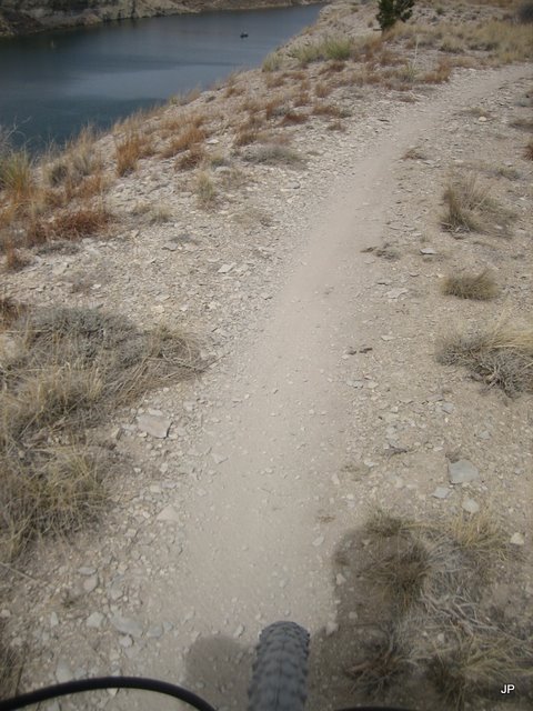
Here is a better picture on the trail and small sharp rocks--there is cactus everywhere too so watch on the passing. Plenty of sections with short double track to pass/relax throughout the loop so take advantage there--otherwise on these narrow trails with the sharp rock and spines, I do not recommend venturing too far off trail. We are on the Outer Limits loop now here--trail looks and feels just the same.

Cliff bike diving? Could be fun but with the Moots...maybe not.

David cruising the trail ahead. Once you get out to the point on Outer Limits the trail turns to double track until you get to the waterfall trail to the left. Here you can fly and use to eat/recover/pass.
Bottom of waterfall trail--short water section and nice bridge. There is a split coming down the waterfall trail at the bottom (about 400 feet before the above bridge) when you see the water--take the high road to the right or you will be swimming as I almost did. David got it right--I had to climb up steep slope about 15 feet to join him!

After the bridge at Waterfall you take a left, then a right at the next junction until you hit the bottom of Rock Canyon. Here David is cranking up a small rock section. There are a few and require a little power so make sure you have hydrated well and keep breathing to keep from cramping. This a nice long climb up tot he top of Arkansas Point and then you descend back down-- a little kicker at the end of the 35 mile loop.

Coming up Rock Canyon

Near Roller Coaster looping the mesa.

End of Roller Coaster and near start of Edge trail. You can see the canyons have some super cool stuff to play on--the race avoids these and only takes the easier canyons with the log bridges and big rock drops. I highly recommend coming back some time to play on them though--very nicely built.

Descending Stone Henge--appropriately named. You come around the corner and its surreal with these rock cairns built up.

Picture window!


Here we are just after finishing the Stonehenge trail and riding the South Shore trail back to Conduit and the car. A nice loop for sure they put together and great mix of the trails. For sure save the energy to climb back up the Rock Canyon/Stonehenge loop at the end and for the short steep climbs up and down on South Shore back to the start/finish. This loop is going to be tough twice and with the up/down all day on the trials, it wears at you so be ready--no real long climbs or long descents--all just short and steady. Trails rock though and remind me of riding 35 miles of Kestle run at 18road in Fruita--forever pump track.

(Click on images for larger one)
The loop was 33.5 miles and we had 1900ft of climbing per lap from my bike computer. Lap time was 3.5 hours at our slack pace plus a bit more for some picture taking/chatting with other riders and picking up tools/tubes--by the end of the ride, we had almost a new tool kit from the items dropped on the trail that day! A super fun day and worth the effort. Hope to head back in late April.


Tuesday, March 15, 2011

Gettin that single track fix...

Clock goes off at 5:30am...its Sunday, and what is this, the ground is all wet, its socked in, and kind of chilly. The husky dog wants out, so much for sleeping in on the weekend. It is not that bad I tell my self walking around the neighborhood, we can still ride (I think?). I make some waffles, eat a banana and get dressed anyway. Toby calls at 7am--he is out front ready to go, so yes, we are going riding.....


And an awesome ride it was! Could not believe the conditions on the trail Sunday. We headed up to Devil's Backbone in Loveland--a place I have spent some serious time playing on and even building trail over the years. Pulled up in the parking lot and there are only a few cars and it looks like rain any second. We both completely over pack clothing not knowing what will happen and head off down the trail to see how things are.

The trail starts out with a nice few short climbs and then a gradual climb for about a mile. You turn a corner and bam, you climb 300 feet in 0.7 miles--nice warm up! Several serious switch backs to boot, with rocks, and more than the eyes want to look at while climbing.

Toby almost at the top
Cresting the top of the first big climb. Clouds still looked a bit iffy here.

One thing DBB has--techy as can be, plus swoopy buffed out single track you could pave.
Yep, techy for sure, but all very doable...with the right set of gymnastics crash pads appropriately places! We both gawked at this and decided to move on. ;)

Here Toby and I are just after the North side of the DBB park entering the Blue Sky trail.

This is looking North to Horestooth Mountain park. The Blue Sky trail follows this valley all the way there for about 7 miles.

Some great trail work was done here to sustain this great connector!
We opted for the Indian Summer loop about half way between the DBB and Horsetooth which climbs to the west on a nice Mesa and then drops back down. Toby topped out here--all smiles.
Crazy blue birds on the trail--neither one of us can identify them.

Then sun came out! We dropped into Horsetooth and the camp ground and stopped for some food. Chatted it up with a runner and then headed back to DBB. There are sections of the Blue Sky trail that have these large boulders the trail weaves in and out of. Great terrain, both directions and super fun.

Hero dirt today--best I have ever ridden up this way--not one bit of dust, amazing traction on the steeps and just perfectly tacky--plus again, no one on the trails! The rocks were a little slippery here and there, but again, amazing conditions!

Toby railing through some more rocks. It was hard to stop smiling and laughing here.

A few nice water bars and drops to climb back up and over on the way to the car. That chain ring is mighty close!

Just after the above section, there is another little tricky spot.....keep cranking...keep cranking

Well..almost, half crank more and it was all there--maybe I will clean it next time!

Yeah, that was fun!


Our ride from the sky, Blue Sky that is.

20 miles later, 2K of climbing, and 3+ hours, bikes and riders were all content all before 1pm! We ended the day with a short visit to Larry at Mountain High Cyclery in Loveland before trekking back to Longmont. Single track fix, CHECK!!


Sunday, January 9, 2011

I've just started my third year as a BSV member and I have yet to contribute to the blog. I have been included in other blog postings, thanks to John P, and I'm trying to emulate his discipline here in the New Year, not just by contributing to the team blog but also by having my own as well (which has a lot more about this patricular ride at http://nohosing.blogspot.com/).

So here's my first contribution, a fun solo ride I did this Saturday just before we got hit by another blast of winter weather. Speaking of John P I tried to coerce him into joining in but he had ski plans. I would have of course extended an invitation to all of BSV but this route was a last minute decision. I really need to get better about planning things more in advance...

A winter day with highs in the 40s is a good day for a canyon climb. It's always good to get some climbing in occasionally throughout the winter, so it's not such a shock when you make that annual spring trip to Fruita. So with Saturday's great weather, it was just a question of "which canyon to climb"?

Four Mile canyon and Sunshine canyons were the choice for today. Starting and ending in Boulder with Gold Hill as the mid-point, this is a great ride with good views, little traffic, and some reasonably steep sections. I call this ride the "super Poorman", borrowing from the colloquial phrase "super Walker" (another awesome ride) which involves riding Walker ranch starting from Boulder, climbing Flagstaff to get there. In this case, climbing Four Mile, connecting to Sunshine by way of Poorman Road, and dropping back to town is a popular loop, but Gold Hill is a much longer alternative to the same basic concept.

The ride started with a gradual climb west up Boulder creek trail, dodging peds, dogs, and patches of ice. Here's the end of city maintenance, things get more fun from this point:


Finally, something more interesting than pavement and crusher fine:


Then begins the long climb up Four Mile canyon. This climb is all asphalt though the end of Salina, then it changes to dirt which is typically snow packed this time of year, and fun to ride. I had forgotten about the fire that happened in this area last year until I started seeing the damage. I realized I hadn't been this way since this happened. Here's just one small sample:


Just below Salina, here's where we turn off onto Gold Rim road:


Passing through Salina:


Except perhaps for "Cold Beer" this is the best sign you can ever see. But where's the snow pack typical for this time of year?? Guess it really has been dry here on the Front Range lately:


Just past Gold Hill, near the high point of the day looking backwards to a nice view of the Indian Peaks. A great view is all the sweeter when earned:


At the top, a good place to pee, put on a coat, balaclava, and dry gloves. Oh, and double check that my quick releases are on tight and take a gratuitous shot of the rider and bike. Perhaps I should pick a more level rock next time for the camera:


I was too busy enjoying the downhill and avoiding sand to take many more pictures, but here's one. The fire damage appears to have been the worst here at the top of Sunshine canyon. My thoughts go out to all those who lost their homes, and the heroic efforts of the fire fighters who saved so many others:


Done! Time to scare up some food:


Here's a map of the route and some ride stats:

Distance = 25.7 miles
Total ascent - 3380 ft.
Max elevation = 8492 ft.
Moving time = 2 hr. 41 min.
Total snot rockets blown = 27 (what, your GPS doesn't measure this?)